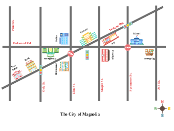
This illustrated map provides a detailed layout of The City of Magnolia, showcasing the city's infrastructure with clearly marked streets and icons for essential services and amenities. The map includes various public service buildings and commercial establishments, which are integral to city life, such as the police station, post office, bank, and school. The inclusion of traffic signals and stop signs helps with navigation and urban planning. This map can be used for directional guidance, educational purposes, urban development planning, or as a part of a welcome kit for new residents.


 Desktop